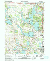
1992 Map of Angola West
USGS Topo · Published 1993About this map
Pokagon State Park and the intricate basins of Lake James anchor this northern Indiana landscape during the early 1990s. The map illustrates a high density of recreational and seasonal settlements, including Glen Eden, Panama, and Inverness, alongside significant educational and public infrastructure like Tri-State University and the Tri-State County Municipal Airport. The transition from rural agriculture to lake-oriented tourism is evident in the numerous campgrounds, such as the Yogi Bear Jellystone Park Campgrounds, and the presence of the Valley Outlet Center near the intersection of major transit routes.
Find a feature on this map
86 named features on this map. Tap any name to fly to it.
Don’t see what you’re looking for? This feature index may not catch every label — zoom into the map to look around manually.
Map Details
Editions of this 1992 Angola West Map
2 editions found
Other maps of this area

1939 · Hamilton
USGS Topo · 1:24,000

1939 · Angola East
USGS Topo · 1:24,000

1940 · Orland
USGS Topo · 1:24,000

1941 · Orland
USGS Topo · 1:24,000

1941 · Angola West
USGS Topo · 1:24,000

1942 · Ashley
USGS Topo · 1:24,000

1942 · Angola West
USGS Topo · 1:24,000

1942 · Stroh
USGS Topo · 1:24,000

1947 · Angola East
USGS Topo · 1:24,000

1948 · Hamilton
USGS Topo · 1:24,000