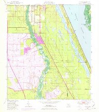
1948 Map of Ankona
USGS Topo · Published 1971About this map
The North Fork St Lucie River meanders through this coastal landscape, creating a distinct boundary between the developing western subdivisions and the mangroves of the eastern shoreline. Originally surveyed in 1948 and updated with 1970 aerial photography, the map documents the early suburban expansion of Port St Lucie and River Park into formerly agricultural or undeveloped marshlands. Further north, the established community of White City sits near the Florida East Coast railway, which parallels the Indian River lagoon. Across the lagoon, the southern tip of Hutchinson Island reveals a wilder terrain of swamps and tidal inlets like Big Mud Creek. Notable infrastructure changes from the post-war era appear in purple revisions, most notably the arrival of Floridas Turnpike and its associated Service Area No 3, which bisected the inland flatwoods.
Find a feature on this map
30 named features on this map. Tap any name to fly to it.
Don’t see what you’re looking for? This feature index may not catch every label — zoom into the map to look around manually.
Map Details
Editions of this 1948 Ankona Map
4 editions found
Other maps of this area

1948 · Palm City
USGS Topo · 1:24,000

1948 · Ankona
USGS Topo · 1:24,000

1948 · St. Lucie Inlet
USGS Topo · 1:24,000

1948 · Eden
USGS Topo · 1:24,000

1949 · Fort Pierce
USGS Topo · 1:24,000

1949 · Fort Pierce NW
USGS Topo · 1:24,000

1950 · St. Lucie Inlet
USGS Topo · 1:24,000

1950 · Ankona
USGS Topo · 1:24,000

1950 · Fort Pierce
USGS Topo · 1:24,000

1950 · Palm City
USGS Topo · 1:24,000