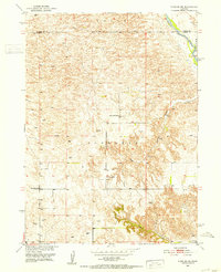
1951 Map of Anselmo NE
USGS Topo · Published 1953About this map
The Middle Loup River winds through the northeastern corner of this Custer County landscape, carving a distinct valley through the Nebraska Sandhills. Surveyed in the early 1950s as part of the Missouri River Basin development program, the area is defined by the townships of Victoria and Edith. This agricultural and ranching terrain is dotted with numerous Windmills, essential for life in the high plains. The map reveals a network of rural education, identifying the Happy Hollow Sch, Cooperville Sch, and Windy Point Sch distributed across the sections. Topographical interest is found in the southeastern corner, where Cedar Canyon and Canyon break the rolling ground, leading toward the Victoria Springs Cem.
Find a feature on this map
11 named features on this map. Tap any name to fly to it.
Don’t see what you’re looking for? This feature index may not catch every label — zoom into the map to look around manually.
Map Details
Editions of this 1951 Anselmo NE Map
3 editions found
Other maps of this area

1951 · Lillian
USGS Topo · 1:24,000

1951 · Anselmo
USGS Topo · 1:24,000

1951 · Anselmo SW
USGS Topo · 1:24,000

1951 · Anselmo NE
USGS Topo · 1:24,000

1951 · Anselmo NW
USGS Topo · 1:24,000

1951 · Milburn
USGS Topo · 1:24,000

1952 · Almeria SW
USGS Topo · 1:24,000

1952 · Brewster SE
USGS Topo · 1:24,000

1952 · Brewster SW
USGS Topo · 1:24,000

1955 · Broken Bow
USGS Topo · 1:250,000