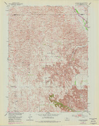
1951 Map of Anselmo NE
USGS Topo · Published 1978About this map
The Middle Loup River winds through the northeast corner of this Nebraska landscape, cutting through the distinctive terrain of Victoria and Edith. This mid-century survey, updated in the late 1970s, reveals a rural infrastructure defined by isolated landmarks and small community centers. Several rural schoolhouses are documented across the township divisions, including Happy Hollow Sch, Cooperville Sch, and Windy Point Sch.
Find a feature on this map
10 named features on this map. Tap any name to fly to it.
Don’t see what you’re looking for? This feature index may not catch every label — zoom into the map to look around manually.
Map Details
Editions of this 1951 Anselmo NE Map
3 editions found
Other maps of this area

1951 · Lillian
USGS Topo · 1:24,000

1951 · Anselmo
USGS Topo · 1:24,000

1951 · Anselmo SW
USGS Topo · 1:24,000

1951 · Anselmo NE
USGS Topo · 1:24,000

1951 · Anselmo NW
USGS Topo · 1:24,000

1951 · Milburn
USGS Topo · 1:24,000

1952 · Almeria SW
USGS Topo · 1:24,000

1952 · Brewster SE
USGS Topo · 1:24,000

1952 · Brewster SW
USGS Topo · 1:24,000

1955 · Broken Bow
USGS Topo · 1:250,000