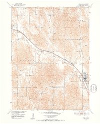
1951 Map of Ansley
USGS Topo · Published 1952About this map
Mud Creek dictates the geography of this Custer County landscape, its meandering path carved through the valley floor and closely followed by the Chicago Burlington and Quincy railroad line. The settlement of Ansley sits at the intersection of this vital rail artery and local routes, serving as the primary hub for the surrounding agricultural townships. To the northwest, the smaller village of Berwyn marks the rail line's exit from the quadrangle.
Find a feature on this map
20 named features on this map. Tap any name to fly to it.
Don’t see what you’re looking for? This feature index may not catch every label — zoom into the map to look around manually.
Map Details
Editions of this 1951 Ansley Map
3 editions found
Other maps of this area

1951 · Broken Bow NE
USGS Topo · 1:24,000

1951 · Westerville
USGS Topo · 1:24,000

1951 · Ansley
USGS Topo · 1:24,000

1951 · Broken Bow SE
USGS Topo · 1:24,000

1951 · Ansley NE
USGS Topo · 1:24,000

1951 · Eddyville NE
USGS Topo · 1:24,000

1951 · Mason City NW
USGS Topo · 1:24,000

1951 · Mason City
USGS Topo · 1:24,000

1951 · Ansley SE
USGS Topo · 1:24,000

1955 · Broken Bow
USGS Topo · 1:250,000