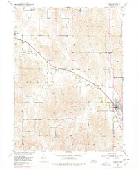
1951 Map of Ansley
USGS Topo · Published 1978About this map
The Burlington Northern railway cuts a distinct diagonal through this Custer County landscape, following the course of Mud Creek from the northwest down toward the settlement of Ansley. This 1951 survey, with revisions from the 1970s, captures a rural Nebraska district defined by a high density of local schoolhouses and family landmarks. Educational life centered around rural institutions like Goose Valley Sch, Spencer Park Sch, and Janesville Sch, serving the surrounding agricultural community. The map reveals the infrastructure of the Missouri River Basin development era, including numerous Windmill sites vital for local livestock and farming. Genealogists can locate specific burial grounds including Janesville Cem and Ansley Cem, while terrain labels like Comer Canyon and Goose Valley illustrate the natural draws and drainages that dictated early settlement patterns near Berwyn.
Find a feature on this map
24 named features on this map. Tap any name to fly to it.
Don’t see what you’re looking for? This feature index may not catch every label — zoom into the map to look around manually.
Map Details
Editions of this 1951 Ansley Map
3 editions found
Other maps of this area

1951 · Broken Bow NE
USGS Topo · 1:24,000

1951 · Westerville
USGS Topo · 1:24,000

1951 · Ansley
USGS Topo · 1:24,000

1951 · Broken Bow SE
USGS Topo · 1:24,000

1951 · Ansley NE
USGS Topo · 1:24,000

1951 · Eddyville NE
USGS Topo · 1:24,000

1951 · Mason City NW
USGS Topo · 1:24,000

1951 · Mason City
USGS Topo · 1:24,000

1951 · Ansley SE
USGS Topo · 1:24,000

1955 · Broken Bow
USGS Topo · 1:250,000