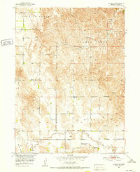
1951 Map of Ansley NE
USGS Topo · Published 1952About this map
The agrarian landscape of Custer County unfolds through this mid-century survey, conducted as part of the Department of the Interior's Missouri River Basin development program. The map documents a period when the rural school system remained the backbone of the community, identifying several local landmarks including Spring Creek Sch, Mt Custer Sch, and Myrtle Sch. These schoolhouses were distributed across established districts like Douglas Grove and Westerville, reflecting a settlement pattern tied closely to the available water and fertile lands of the valley floor.
Find a feature on this map
11 named features on this map. Tap any name to fly to it.
Don’t see what you’re looking for? This feature index may not catch every label — zoom into the map to look around manually.
Map Details
Editions of this 1951 Ansley NE Map
3 editions found

Other maps of this area

1951 · Westerville
USGS Topo · 1:24,000

1951 · Ansley
USGS Topo · 1:24,000

1951 · Ansley NE
USGS Topo · 1:24,000

1951 · Arcadia West
USGS Topo · 1:24,000

1951 · Ansley SE
USGS Topo · 1:24,000

1951 · Arcadia SW
USGS Topo · 1:24,000

1952 · Sargent SE
USGS Topo · 1:24,000

1952 · Comstock
USGS Topo · 1:24,000

1952 · Sargent SW
USGS Topo · 1:24,000

1955 · Broken Bow
USGS Topo · 1:250,000