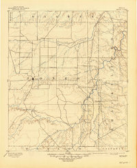
1893 Map of Anson
USGS Topo · Published 1945About this map
Anson serves as the focal point of this late 19th-century survey, surrounded by a landscape defined by cattle country and the winding path of the Clear Fork of Brazos River. The topography of Jones and Shackelford Counties reveals a sparse network of early settlements such as Phantom Hill and Rising Sun, situated along the natural corridors of Deadman Creek and Elm Creek.
Find a feature on this map
36 named features on this map. Tap any name to fly to it.
Don’t see what you’re looking for? This feature index may not catch every label — zoom into the map to look around manually.
Map Details
Editions of this 1893 Anson Map
5 editions found
Other maps of this area

1890 · Abilene
USGS Topo · 1:125,000

1891 · Anson
USGS Topo · 1:125,000

1892 · Abilene
USGS Topo · 1:125,000

1892 · Albany
USGS Topo · 1:125,000

1893 · Albany
USGS Topo · 1:125,000

1893 · Roby
USGS Topo · 1:125,000

1893 · Anson
USGS Topo · 1:125,000

1893 · Sweetwater
USGS Topo · 1:125,000

1931 · Baird
USGS Topo · 1:125,000

1931 · Aspermont
USGS Topo · 1:62,500