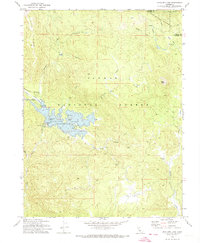
1972 Map of Antelope Lake
USGS Topo · Published 1974About this map
Antelope Lake serves as the centerpiece of this mid-1970s survey within the Plumas National Forest. The map detail includes the Antelope Valley Dam and specialized infrastructure such as the Gaging Station and Boulder Creek Work Center. Evidence of the region’s timber and ranching history is preserved through labels like Fruit Growers Blvd and several named homestead sites, including Wemple Cabin, Frazier Cabin, and Harwood Cabin. High-altitude terrain is defined by the Diamond Mountains and Wildcat Ridge, with Clarks Peak 7179 marking a significant elevation. This edition also highlights the recreational development of the era, featuring Long Point Campground, a Boat Ramp, and Dedication Island, providing a detailed look at the interface between managed wilderness and public utility.
Find a feature on this map
35 named features on this map. Tap any name to fly to it.
Don’t see what you’re looking for? This feature index may not catch every label — zoom into the map to look around manually.
Map Details
Editions of this 1972 Antelope Lake Map
2 editions found
Other maps of this area

1886 · Honey Lake
USGS Topo · 1:250,000

1891 · Honey Lake
USGS Topo · 1:250,000

1893 · Honey Lake
USGS Topo · 1:250,000

1950 · Kettle Rock
USGS Topo · 1:62,500

1950 · Milford
USGS Topo · 1:62,500

1954 · Susanville
USGS Topo · 1:62,500

1954 · Litchfield
USGS Topo · 1:62,500

1955 · Westwood
USGS Topo · 1:250,000

1958 · Westwood
USGS Topo · 1:250,000

1959 · Westwood
USGS Topo · 1:250,000