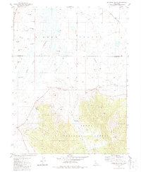
1981 Map of Antelope Valley
USGS Topo · Published 1988About this map
Tahoe National Forest meets the flat, water-rich expanse of Sierra Valley in this detailed topographic study. The landscape is defined by its complex hydrology, where numerous Flowing Wells and a network of Channels and Canals manage the transition between the high ground and the valley floor. To the east, the Western Pacific railroad cuts a straight path through the lowlands, serving as a primary transportation artery through this rural corridor. Significant landmarks like Lombardi Point and Palen Reservoir anchor the central portion of the map, while Rice Hill and TV Hill rise above the surrounding terrain. This survey captures a moment when traditional land use, represented by isolated springs and drill holes, coexisted with modern infrastructure such as the Sewage Disposal Ponds near Smithneck Creek, illustrating the managed nature of this high-altitude basin.
Find a feature on this map
23 named features on this map. Tap any name to fly to it.
Don’t see what you’re looking for? This feature index may not catch every label — zoom into the map to look around manually.
Map Details
Editions of this 1981 Antelope Valley Map
3 editions found
Other maps of this area

1890 · Sierraville
USGS Topo · 1:125,000

1892 · Sierraville
USGS Topo · 1:125,000

1894 · Sierraville
USGS Topo · 1:125,000

1950 · Chilcoot
USGS Topo · 1:62,500

1950 · Portola
USGS Topo · 1:62,500

1955 · Loyalton
USGS Topo · 1:62,500

1955 · Sierraville
USGS Topo · 1:62,500

1958 · Chico
USGS Topo · 1:250,000

1960 · Chico
USGS Topo · 1:250,000
1972 · Portola
USGS Topo · 1:24,000