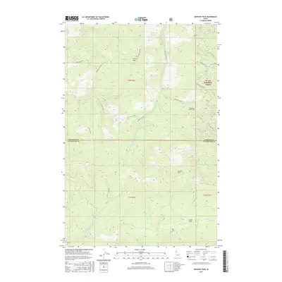
2017 Map of Anthony Peak
USGS Topo · Published 2017About this map
St Joe National Forest dominates this mountain landscape, where the headwaters of several major drainages originate. High points like Anthony Peak and Hemlock Butte define the watershed divides, separating the northern-flowing Middle Fork Saint Maries River from the E Fork Potlatch River system to the southwest. The map illustrates a contemporary pattern of forest access, characterized by a dense network of off-highway vehicle routes such as Stony Butte Ohv and Little Rock Ohv. This infrastructure, alongside primary forest arteries like St Maries River Rd, reflects the area's modern role as a hub for resource management and backcountry recreation. In the lower reaches, labels like Upper Basin and Telephone Booth Hill provide specific identifiers for landforms within this heavily timbered terrain, while the county line between Shoshone and Clearwater bisects the southern portion of the quadrangle.
Find a feature on this map
39 named features on this map. Tap any name to fly to it.
Don’t see what you’re looking for? This feature index may not catch every label — zoom into the map to look around manually.
Map Details
Editions of this 2017 Anthony Peak Map
This is the sole edition of this map. No revisions or reprints were ever made.
Other maps of this area

1955 · Pullman
USGS Topo · 1:250,000

1955 · Spokane
USGS Topo · 1:250,000

1958 · Spokane
USGS Topo · 1:250,000

1958 · Pullman
USGS Topo · 1:250,000

1961 · Fernwood
USGS Topo · 1:62,500

1961 · Bovill
USGS Topo · 1:62,500

1969 · Elk River
USGS Topo · 1:24,000
1969 · Elk Butte
USGS Topo · 1:24,000

1969 · Anthony Peak
USGS Topo · 1:24,000

1969 · Grandmother Mtn
USGS Topo · 1:24,000