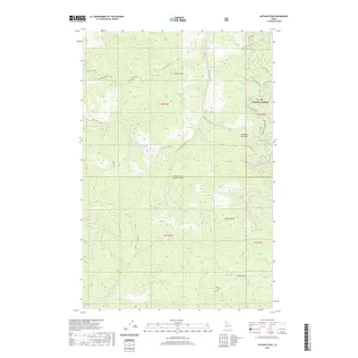
2020 Map of Anthony Peak
USGS Topo · Published 2020About this map
Anthony Peak rises as a central landmark within the high timberlands of the St Joe National Forest, marking a landscape defined by the divide between several significant watersheds. The northern sections of the map are drained by Anthony Creek and Dutch Creek, while the central drainage of the Middle Fork Saint Maries River cuts through the terrain. To the south, the headwaters of the E Fork Potlatch River emerge, illustrating the complex hydrology of this mountainous region on the border of Shoshone and Clearwater counties. A network of forest development roads and specialized trails, such as Anthony Peak Ohv and Stony Butte Ohv, indicates a modern era of timber management and back-country access. High elevation features like Hemlock Butte and the curiously named Telephone Booth Hill provide specific points of interest for navigating this densely forested interior.
Find a feature on this map
41 named features on this map. Tap any name to fly to it.
Don’t see what you’re looking for? This feature index may not catch every label — zoom into the map to look around manually.
Map Details
Editions of this 2020 Anthony Peak Map
This is the sole edition of this map. No revisions or reprints were ever made.
Other maps of this area

1955 · Pullman
USGS Topo · 1:250,000

1955 · Spokane
USGS Topo · 1:250,000

1958 · Spokane
USGS Topo · 1:250,000

1958 · Pullman
USGS Topo · 1:250,000

1961 · Fernwood
USGS Topo · 1:62,500

1961 · Bovill
USGS Topo · 1:62,500

1969 · Elk River
USGS Topo · 1:24,000
1969 · Elk Butte
USGS Topo · 1:24,000

1969 · Anthony Peak
USGS Topo · 1:24,000

1969 · Grandmother Mtn
USGS Topo · 1:24,000