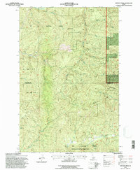
1994 Map of Anthony Peak
USGS Topo · Published 1997About this map
St Joe National Forest dominates this high-elevation terrain where the headwaters of several critical Idaho water systems originate. Surveyed and revised by the U.S. Forest Service in the 1990s, the map illustrates a landscape defined by significant peaks like Anthony Peak and Hemlock Butte. This area serves as a hydrological divide, sending water north via the Middle Fork St Maries River and south into the drainage of the Potlatch River and the East Fork Potlatch River. The transition between Shoshone and Clearwater counties is marked by a network of forest roads and trails that traverse the ridgelines, including the curiously named Telephone Booth Hill. The inclusion of Floodwood State Forest and various Springs suggests a wilderness area managed for both timber and water resources, with minor industrial activity indicated by a Gravel Pit near the southern boundary.
Find a feature on this map
27 named features on this map. Tap any name to fly to it.
Don’t see what you’re looking for? This feature index may not catch every label — zoom into the map to look around manually.
Map Details
Editions of this 1994 Anthony Peak Map
This is the sole edition of this map. No revisions or reprints were ever made.
Other maps of this area

1955 · Pullman
USGS Topo · 1:250,000

1955 · Spokane
USGS Topo · 1:250,000

1958 · Spokane
USGS Topo · 1:250,000

1958 · Pullman
USGS Topo · 1:250,000

1961 · Fernwood
USGS Topo · 1:62,500

1961 · Bovill
USGS Topo · 1:62,500

1969 · Elk River
USGS Topo · 1:24,000
1969 · Elk Butte
USGS Topo · 1:24,000

1969 · Anthony Peak
USGS Topo · 1:24,000

1969 · Grandmother Mtn
USGS Topo · 1:24,000