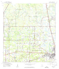
1944 Map of Antioch
USGS Topo · Published 1963About this map
Plant City anchors the southeastern corner of this mid-century survey, revealing a landscape defined by the intersection of the Atlantic Coast Line and Seaboard Air Line railroads. The map documents a transition from the developing urban grid of the city to the rural expanses of the Cork Prairie and the numerous small settlements that once served this agricultural region. Local history is deeply embedded in the rural infrastructure, seen in institutions like the Cork Academy and Antioch Sch, alongside multiple community centers such as Antioch, Moriczville, and Knights. Waterways including Baker Creek and Pemberton Creek wind through the terrain, which is dotted with numerous small ponds and depressions. For genealogists, the map is a precise record of burial sites and congregations, including Oak Lawn Cem, the American Legion Cem, and Mt Zion Ch.
Find a feature on this map
30 named features on this map. Tap any name to fly to it.
Don’t see what you’re looking for? This feature index may not catch every label — zoom into the map to look around manually.
Map Details
Editions of this 1944 Antioch Map
3 editions found
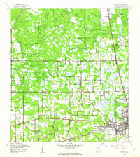
Other maps of this area

1921 · Tampa
USGS Topo · 1:62,500

1943 · Thonotosassa
USGS Topo · 1:24,000

1944 · Plant City
USGS Topo · 1:31,680

1944 · Mango
USGS Topo · 1:31,680

1944 · Wesley Chapel
USGS Topo · 1:31,680

1944 · Thonotosassa
USGS Topo · 1:31,680

1944 · Antioch
USGS Topo · 1:31,680

1944 · Socrum
USGS Topo · 1:31,680

1947 · Zephyrhills
USGS Topo · 1:24,000

1955 · Nichols
USGS Topo · 1:24,000