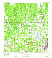
1944 Map of Antioch
USGS Topo · Published 1963About this map
Plant City serves as the bustling commercial anchor in this mid-century survey of Hillsborough County, showing the intersection of the Atlantic Coast Line and Seaboard Air Line railroads. The surrounding landscape is a mosaic of citrus groves and wetlands, where the hydrologic network of Pemberton Creek, Baker Creek, and Turkey Creek drains toward the southwestern corner. Small communities and rural junctions such as Antioch, Knights, and Moriczville are depicted with their essential civic structures, including the Antioch Sch and Knights Sch.
Find a feature on this map
34 named features on this map. Tap any name to fly to it.
Don’t see what you’re looking for? This feature index may not catch every label — zoom into the map to look around manually.
Map Details
Editions of this 1944 Antioch Map
3 editions found
Other maps of this area

1921 · Tampa
USGS Topo · 1:62,500

1943 · Thonotosassa
USGS Topo · 1:24,000

1944 · Plant City
USGS Topo · 1:31,680

1944 · Mango
USGS Topo · 1:31,680

1944 · Wesley Chapel
USGS Topo · 1:31,680

1944 · Thonotosassa
USGS Topo · 1:31,680

1944 · Antioch
USGS Topo · 1:31,680

1944 · Socrum
USGS Topo · 1:31,680

1947 · Zephyrhills
USGS Topo · 1:24,000

1955 · Nichols
USGS Topo · 1:24,000