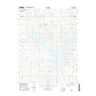
2015 Map of Antioch
USGS Topo · Published 2015About this map
Hillsdale Lake dominates the southern landscape of this quadrangle, its many inlets and fingers reaching into the surrounding terrain where Johnson and Miami Counties meet. The settlement of Antioch sits along W 223rd St, serving as a central point for the region's network of country roads. Genealogical interest is particularly high here, with several distinct burial sites including the Antioch Cem, the Scotts Valley Cem, and the Marysville Cem - Old. The land is heavily marked by water systems, from the meandering Bull Cr to various smaller tributaries like Fuggle Br and Granny Br. To the northwest, the town of Edgerton is visible at the map's edge, while the Hayden Farm Airport serves as a notable local aviation landmark amidst the rural landscape.
Find a feature on this map
59 named features on this map. Tap any name to fly to it.
Don’t see what you’re looking for? This feature index may not catch every label — zoom into the map to look around manually.
Map Details
Editions of this 2015 Antioch Map
This is the sole edition of this map. No revisions or reprints were ever made.
Other maps of this area

1885 · Lawrence
USGS Topo · 1:125,000

1887 · Olathe
USGS Topo · 1:125,000

1889 · Lawrence
USGS Topo · 1:125,000

1893 · Olathe
USGS Topo · 1:125,000

1947 · Lawrence
USGS Topo · 1:250,000

1950 · Lawrence
USGS Topo · 1:250,000

1956 · Wellsville
USGS Topo · 1:24,000
1956 · Ocheltree
USGS Topo · 1:24,000

1956 · Paola East
USGS Topo · 1:24,000
1956 · Edgerton
USGS Topo · 1:24,000