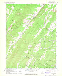
1967 Map of Antioch
USGS Topo · Published 1972About this map
The Nancy Hanks Memorial marks a significant historical site in this portion of West Virginia, situated amidst the dramatic geography of the Allegheny Front. The landscape is dominated by the massive parallel formations of New Creek Mountain and Welton Ridge, which dictate the placement of human settlements and transport corridors. Communities like New Creek and Claysville follow the valley of the waterway also named New Creek, while the village of Antioch sits tucked near the eastern foothills. This 1960s-era documentation shows a rural economy supported by land-intensive industries, indicated by a Strip Mine and several quarries. Local connectivity is maintained through the Knobly Road and various mountain passes such as Grayson Gap and Chamberlin Gap. Small community centers are anchored by landmarks like Sunnyside Ch and Clayville Ch, reflecting the deep-rooted local history of Mineral County.
Find a feature on this map
40 named features on this map. Tap any name to fly to it.
Don’t see what you’re looking for? This feature index may not catch every label — zoom into the map to look around manually.
Map Details
Editions of this 1967 Antioch Map
2 editions found
Other maps of this area

1891 · Romney
USGS Topo · 1:125,000

1895 · Piedmont
USGS Topo · 1:125,000

1919 · Elk Garden
USGS Topo · 1:48,000

1920 · Elk Garden
USGS Topo · 1:48,000

1920 · Moorefield
USGS Topo · 1:62,500

1920 · Keyser
USGS Topo · 1:62,500

1921 · Keyser
USGS Topo · 1:48,000

1921 · Greenland Gap
USGS Topo · 1:62,500

1921 · Moorefield
USGS Topo · 1:48,000

1922 · Elk Garden
USGS Topo · 1:62,500