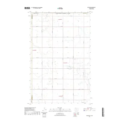
2017 Map of Antler NW
USGS Topo · Published 2017About this map
Bottineau County and neighboring Renville County meet in this northern plains landscape along the United States-Canada border. This 2017 survey reflects the persistent agricultural grid that defines the region, where section lines are traced by long stretches of gravel roads such as 109th St NW and Co Rd 3A. The terrain is characterized by prairie wetlands and the winding path of Cut Bank Creek, which meanders through the southwestern corner. One of the few non-boundary landmarks is Haas Cemetery, located just off 102nd St NW, serving as a quiet witness to the generations of families who settled these borderlands. The map provides a precise look at the township and range system, marking transitions between t164n r83w and surrounding districts in an area where the landscape remains largely defined by its original survey lines.
Find a feature on this map
25 named features on this map. Tap any name to fly to it.
Don’t see what you’re looking for? This feature index may not catch every label — zoom into the map to look around manually.
Map Details
Editions of this 2017 Antler NW Map
This is the sole edition of this map. No revisions or reprints were ever made.
Other maps of this area

1948 · Dokken SW
USGS Topo · 1:24,000

1948 · Mohall
USGS Topo · 1:24,000

1949 · Mohall NE
USGS Topo · 1:24,000

1950 · Antler NW
USGS Topo · 1:24,000

1950 · Mohall
USGS Topo · 1:62,500

1950 · Antler
USGS Topo · 1:24,000
1950 · Renville
USGS Topo · 1:24,000

1954 · Minot
USGS Topo · 1:250,000

1958 · Minot
USGS Topo · 1:250,000
2011 · Renville
USGS Topo · 1:24,000