
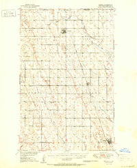
1950 Map of Mohall
USGS Topo · Published 1950About this map
The international border between the Canada and United States defines the northern edge of this Renville County landscape, where the prairie transitions into the agricultural townships of Colquhoun, Eden Valley, and Hamerly. The survey reflects a mid-century rural economy anchored by the Great Northern railroad, which links the northern outpost of Sherwood to the southern hub of Mohall. Small, vital community nodes are scattered throughout the grid, marked by local schools and places of worship such as Lutheran Ch and St Johns Ch.
Find a feature on this map
26 named features on this map. Tap any name to fly to it.
Don’t see what you’re looking for? This feature index may not catch every label — zoom into the map to look around manually.
Map Details
Editions of this 1950 Mohall Map
2 editions found
Other maps of this area

1947 · Tolley
USGS Topo · 1:62,500

1948 · Dokken SW
USGS Topo · 1:24,000

1948 · Mohall
USGS Topo · 1:24,000

1948 · Tolley
USGS Topo · 1:24,000

1948 · Lansford
USGS Topo · 1:62,500

1949 · Lansford NW
USGS Topo · 1:24,000

1949 · Mohall SW
USGS Topo · 1:24,000

1949 · Mohall NE
USGS Topo · 1:24,000

1949 · Sherwood
USGS Topo · 1:24,000

1949 · Greene
USGS Topo · 1:24,000