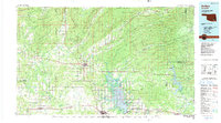
1985 Map of Antlers
USGS Topo · Published 1991About this map
Antlers serves as the focal point for this Southeast Oklahoma landscape, situated at the crossroads of regional transit and the winding Kiamichi River. The topography is dominated by the prominent ridges of Blackjack Mountain and the distinctive geological formations of the Potato Hills. To the south and east, the impoundment of the Kiamichi River forms the extensive waters of Hugo Lake, while the eastern portion of the map covers the reaches of Pine Creek Lake. These reservoirs represent a significant mid-20th-century transformation of the local hydrology, surrounding the settlements of Belzoni and Sobol. Further north, the Pushmatata State Game Refuge preserves a large tract of upland wilderness. The map also records numerous rural communities like Farris, Nashoba, and Jumbo, illustrating a settlement pattern deeply tied to the valleys of the Little River and Muddy Boggy Creek.
Find a feature on this map
91 named features on this map. Tap any name to fly to it.
Don’t see what you’re looking for? This feature index may not catch every label — zoom into the map to look around manually.
Map Details
Editions of this 1985 Antlers Map
2 editions found
Other maps of this area

1896 · Coalgate
USGS Topo · 1:125,000

1898 · McAlester
USGS Topo · 1:125,000

1899 · Coalgate
USGS Topo · 1:125,000

1899 · Atoka
USGS Topo · 1:125,000

1900 · Atoka
USGS Topo · 1:125,000

1900 · Coalgate
USGS Topo · 1:125,000

1900 · Winding Stair
USGS Topo · 1:125,000

1901 · Antlers
USGS Topo · 1:125,000

1901 · Tuskahoma
USGS Topo · 1:125,000

1901 · Alikchi
USGS Topo · 1:125,000