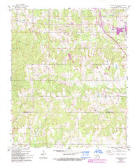
1961 Map of Antlers West
USGS Topo · Published 1993About this map
The town of Antlers serves as the focal point of this 1960s landscape, situated just north of the county line separating Pushmataha Co and Choctaw Co. The terrain is defined by a dense network of drainage systems, including the winding paths of Beaver Creek and Dumpling Creek, which carve through the region's topography. Transportation developments are visible with the Indian Nation Toll Road Turnpike cutting across the northeast, reflecting mid-century infrastructure growth alongside more localized features like the Antlers Municipal Airport and a smaller Landing Strip.
Find a feature on this map
20 named features on this map. Tap any name to fly to it.
Don’t see what you’re looking for? This feature index may not catch every label — zoom into the map to look around manually.
Map Details
Editions of this 1961 Antlers West Map
2 editions found
Other maps of this area

1901 · Antlers
USGS Topo · 1:125,000

1912 · Antlers
USGS Topo · 1:125,000

1925 · Antlers
USGS Topo · 1:125,000

1950 · Mcalester
USGS Topo · 1:250,000

1957 · Farris
USGS Topo · 1:24,000

1957 · Moyers
USGS Topo · 1:24,000
1961 · Darwin
USGS Topo · 1:24,000

1961 · Antlers East
USGS Topo · 1:24,000

1961 · Antlers West
USGS Topo · 1:24,000

1962 · McAlester
USGS Topo · 1:250,000