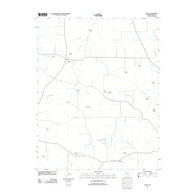
2011 Map of Anutt
USGS Topo · Published 2011About this map
Anutt and Hedrick anchor this rural landscape in the Missouri Ozarks, a region defined by its complex drainage network and numerous family burial grounds. The terrain is marked by deep hollows including Alder Hollow, Elk Hollow, and Rocky Pond Hollow, which channel water toward major branches such as the Dry Fork and Barnitz Prong. The distribution of cemeteries across the township, from the northern Bingham Cemetery to Wofford Cemetery in the southwest, suggests a long history of family homesteads scattered throughout the wooded draws. Notable infrastructure includes the Green Dam and a central Landing Strip, reflecting both agricultural water management and modern rural utility. This survey provides a precise account of the county road system, illustrating how routes like Co RD-213a and Co RD-233 follow the natural ridges and creek beds to connect these isolated settlements.
Find a feature on this map
51 named features on this map. Tap any name to fly to it.
Don’t see what you’re looking for? This feature index may not catch every label — zoom into the map to look around manually.
Map Details
Editions of this 2011 Anutt Map
This is the sole edition of this map. No revisions or reprints were ever made.
Other maps of this area

1912 · Rolla
USGS Topo · 1:62,500

1928 · Meramec Spring
USGS Topo · 1:62,500

1937 · Edgar Springs
USGS Topo · 1:48,000

1941 · Salem
USGS Topo · 1:62,500

1945 · Salem
USGS Topo · 1:62,500

1945 · Edgar Springs
USGS Topo · 1:62,500

1949 · Rolla
USGS Topo · 1:250,000

1949 · Meramec Spring
USGS Topo · 1:62,500
1950 · Yancy Mills
USGS Topo · 1:24,000
1951 · Yancy Mills
USGS Topo · 1:24,000