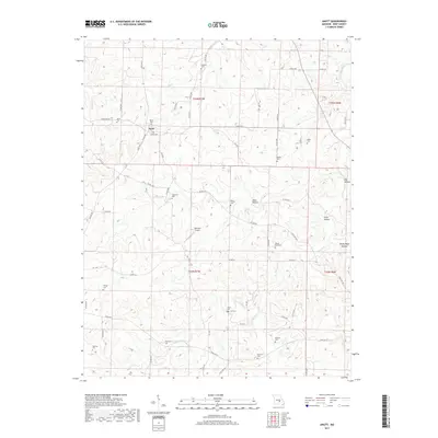
2017 Map of Anutt
USGS Topo · Published 2017About this map
Anutt serves as the central hub for this corner of Dent County, surrounded by a landscape defined by deeply etched drainages and family legacies. The topography is marked by distinctive features such as Alder Hollow, Price Hollow, and Rocky Pond Hollow, which channel water toward larger systems like Dry Fork and the Barnitz Prong. This 2017 survey reveals a high concentration of small family and community burial grounds, including the Bingham Cem, Inman Cem, and Headrick Cem, many situated on ridges overlooking the hollows. These sites, along with landmarks like Domeyer Airport, provide valuable anchor points for researchers tracing the historical footprint of rural Missouri. The network of county roads, such as Co RD 233 and Co RD 2100, follows the natural contours of the land, illustrating the long-standing relationship between the area's difficult terrain and its local transportation patterns.
Find a feature on this map
71 named features on this map. Tap any name to fly to it.
Don’t see what you’re looking for? This feature index may not catch every label — zoom into the map to look around manually.
Map Details
Editions of this 2017 Anutt Map
This is the sole edition of this map. No revisions or reprints were ever made.
Other maps of this area

1912 · Rolla
USGS Topo · 1:62,500

1928 · Meramec Spring
USGS Topo · 1:62,500

1937 · Edgar Springs
USGS Topo · 1:48,000

1941 · Salem
USGS Topo · 1:62,500

1945 · Salem
USGS Topo · 1:62,500

1945 · Edgar Springs
USGS Topo · 1:62,500

1949 · Rolla
USGS Topo · 1:250,000

1949 · Meramec Spring
USGS Topo · 1:62,500
1950 · Yancy Mills
USGS Topo · 1:24,000
1951 · Yancy Mills
USGS Topo · 1:24,000