
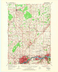
1955 Map of Appleton
USGS Topo · Published 1957About this map
The Fox River corridor anchors this mid-century survey, revealing the industrial and residential core of Appleton, Kimberly, and Kaukauna. The river's power is evidenced by the development of Combined Locks and Little Chute, while the surrounding landscape of Outagamie County remains primarily agricultural. To the west, the Outagamie County Airport and the emerging neighborhoods of Bell Heights and Whispering Pines suggest post-war suburban expansion.
Find a feature on this map
95 named features on this map. Tap any name to fly to it.
Don’t see what you’re looking for? This feature index may not catch every label — zoom into the map to look around manually.
Map Details
Editions of this 1955 Appleton Map
2 editions found
Other maps of this area

1911 · Neenah
USGS Topo · 1:62,500

1954 · De Pere
USGS Topo · 1:62,500

1954 · Chilton
USGS Topo · 1:62,500

1954 · Green Bay
USGS Topo · 1:62,500

1955 · Neenah
USGS Topo · 1:62,500

1955 · Embarrass
USGS Topo · 1:48,000

1955 · Appleton
USGS Topo · 1:24,000

1955 · Neenah
USGS Topo · 1:24,000

1955 · Seymour
USGS Topo · 1:62,500

1955 · Green Bay
USGS Topo · 1:250,000