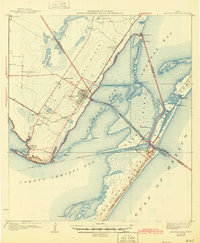
1925 Map of Aransas Pass
USGS Topo · Published 1945About this map
Live Oak Ridge dominates the western coastline of this 1923 survey, serving as the topographical spine for early settlements like Aransas Pass and Ingleside. The region's economy at this time was defined by its connection to the sea and rail, with the San Antonio and Aransas Pass railroad terminating near the coast. A Draw Bridge spans the water toward Hog Island Bay, connecting the mainland to the complex maritime infrastructure of Port Aransas and the United States Military Reservation on Mustang Island.
Find a feature on this map
52 named features on this map. Tap any name to fly to it.
Don’t see what you’re looking for? This feature index may not catch every label — zoom into the map to look around manually.
Map Details
Editions of this 1925 Aransas Pass Map
3 editions found
Other maps of this area

1925 · Aransas Pass
USGS Topo · 1:62,500

1925 · Oso Creek
USGS Topo · 1:62,500

1925 · Corpus Christi
USGS Topo · 1:62,500

1950 · Corpus Christi
USGS Topo · 1:250,000

1951 · Portland
USGS Topo · 1:24,000

1951 · Corpus Christi
USGS Topo · 1:62,500

1951 · Crane Islands NW
USGS Topo · 1:24,000

1951 · Oso Creek NE
USGS Topo · 1:24,000

1951 · Allyns Bight
USGS Topo · 1:24,000

1951 · Oso Creek
USGS Topo · 1:62,500