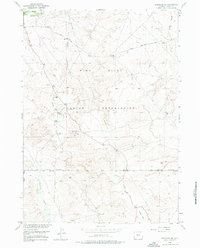
1958 Map of Arapahoe NE
USGS Topo · Published 1976About this map
The Wind River Indian Reservation landscape is defined by the industrial expansion of the late 1950s, where extensive networks of Pipeline and scattered Gas Wells cut across the high desert terrain. Along the northern edge, the Little Wind River flows past the Double Dives (Picnic Area) and a Gaging Sta, while the southern reaches are dominated by the meandering Beaver Creek and the deep relief of Sand Gulch.
Find a feature on this map
20 named features on this map. Tap any name to fly to it.
Don’t see what you’re looking for? This feature index may not catch every label — zoom into the map to look around manually.
Map Details
Editions of this 1958 Arapahoe NE Map
3 editions found
Other maps of this area

1950 · Riverton East
USGS Topo · 1:24,000

1951 · Indian Butte
USGS Topo · 1:24,000

1951 · Riverton West
USGS Topo · 1:24,000

1953 · Arapahoe NE
USGS Topo · 1:24,000

1953 · Ninemile Hill
USGS Topo · 1:24,000

1953 · Bringolf Ranch
USGS Topo · 1:24,000

1953 · Arapahoe
USGS Topo · 1:24,000

1953 · Sand Draw
USGS Topo · 1:24,000

1955 · Thermopolis
USGS Topo · 1:250,000

1955 · Lander
USGS Topo · 1:250,000