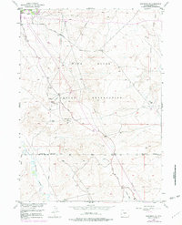
1958 Map of Arapahoe NE
USGS Topo · Published 1979About this map
The Wind River Indian Reservation landscape is defined by the extraction of energy resources across a high desert terrain. This 1958 survey, with revisions into the late 1970s, highlights the industrial footprint of the Gas Hills and numerous Gas Wells and Oil Wells scattered through the sagebrush. The natural hydrology of the Little Wind River and its confluence with Sand Draw provides a stark contrast to the network of modern infrastructure, including a prominent Pipeline and the Sand Draw Road.
Find a feature on this map
19 named features on this map. Tap any name to fly to it.
Don’t see what you’re looking for? This feature index may not catch every label — zoom into the map to look around manually.
Map Details
Editions of this 1958 Arapahoe NE Map
3 editions found
Other maps of this area

1950 · Riverton East
USGS Topo · 1:24,000

1951 · Indian Butte
USGS Topo · 1:24,000

1951 · Riverton West
USGS Topo · 1:24,000

1953 · Arapahoe NE
USGS Topo · 1:24,000

1953 · Ninemile Hill
USGS Topo · 1:24,000

1953 · Bringolf Ranch
USGS Topo · 1:24,000

1953 · Arapahoe
USGS Topo · 1:24,000

1953 · Sand Draw
USGS Topo · 1:24,000

1955 · Thermopolis
USGS Topo · 1:250,000

1955 · Lander
USGS Topo · 1:250,000