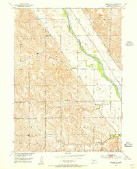
1951 Map of Arcadia SE
USGS Topo · Published 1955About this map
The Middle Loup River valley dominates this landscape in central Nebraska, where a dense network of early rural education centers reflects a once-active homesteading community. Numerous country schools, including Mixed Grove Sch, Turkey Roost Sch, and Sunny Hollow Sch, are scattered across the terrain, serving the townships of Washington, Logan, Elm, and Webster. This 1951 survey reveals the critical role of water management in the region, with Canal No 3 and Canal No 4 cutting across the plains to support local agriculture. The Chicago Burlington and Quincy railroad line follows the river's path, providing a vital transportation link to Loup City. This map is particularly valuable for its detail of named landmarks such as Moon Creek and Cob Creek, which defined the boundaries of rural life during the mid-century era of the Missouri River Basin development program.
Find a feature on this map
24 named features on this map. Tap any name to fly to it.
Don’t see what you’re looking for? This feature index may not catch every label — zoom into the map to look around manually.
Map Details
Editions of this 1951 Arcadia SE Map
4 editions found
Other maps of this area

1899 · Loup
USGS Topo · 1:125,000

1951 · Arcadia SE
USGS Topo · 1:24,000

1951 · Litchfield NE
USGS Topo · 1:24,000

1951 · Arcadia West
USGS Topo · 1:24,000

1951 · Arcadia East
USGS Topo · 1:24,000

1951 · Arcadia SW
USGS Topo · 1:24,000

1951 · Litchfield
USGS Topo · 1:24,000

1953 · Loup City NW
USGS Topo · 1:24,000

1953 · Ravenna NW
USGS Topo · 1:24,000

1953 · Loup City
USGS Topo · 1:24,000