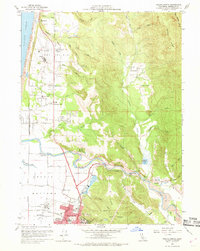
1959 Map of Arcata North
USGS Topo · Published 1969About this map
Arcata Bottoms and the timber-rich hills of Humboldt County define this late-1950s landscape during a period of significant regional growth. The map captures the industrial and educational foundation of the area, featuring the sprawling Humboldt State College campus and various Lumber Mills that drove the local economy. Coastal geography is prominently displayed through the Clam Beach Dunes and the winding course of the Mad River, which supports local infrastructure like the Gaging Station and several gravel pits.
Find a feature on this map
74 named features on this map. Tap any name to fly to it.
Don’t see what you’re looking for? This feature index may not catch every label — zoom into the map to look around manually.
Map Details
Editions of this 1959 Arcata North Map
4 editions found
Other maps of this area

1922 · Eureka
USGS Topo · 1:62,500

1922 · Korbel
USGS Topo · 1:62,500

1925 · Hoopa
USGS Topo · 1:125,000

1933 · Eureka
USGS Topo · 1:48,000

1942 · Eureka
USGS Topo · 1:62,500

1945 · Trinidad
USGS Topo · 1:62,500

1945 · Coyote Peak
USGS Topo · 1:62,500

1945 · Blue Lake
USGS Topo · 1:62,500

1948 · Weed
USGS Topo · 1:250,000

1949 · Eureka
USGS Topo · 1:250,000