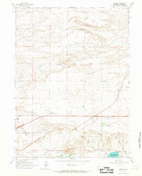
1963 Map of Archer
USGS Topo · Published 1967About this map
The settlement of Archer stands as a central junction on this Laramie County landscape, where the Union Pacific Railroad cuts a diagonal path through the high plains. This early 1960s survey captures an era of agricultural research and ranching, evidenced by the presence of the Univ of Wyoming Experimental Station and the sprawling Wyoming Hereford Ranch. The infrastructure of the era is clearly defined by a network of irrigation systems like Stewart Ditch and Bolln Ditch drawing from Crow Creek.
Find a feature on this map
30 named features on this map. Tap any name to fly to it.
Don’t see what you’re looking for? This feature index may not catch every label — zoom into the map to look around manually.
Map Details
Editions of this 1963 Archer Map
2 editions found
Other maps of this area

1911 · Cheyenne
USGS Topo · 1:125,000

1914 · Cheyenne
USGS Topo · 1:125,000

1950 · Cheyenne
USGS Topo · 1:62,500

1954 · Cheyenne
USGS Topo · 1:250,000

1958 · Cheyenne
USGS Topo · 1:250,000

1961 · Cheyenne South
USGS Topo · 1:24,000

1961 · Cheyenne
USGS Topo · 1:62,500

1961 · Cheyenne North
USGS Topo · 1:24,000

1962 · P O Ranch
USGS Topo · 1:24,000

1963 · Pole Creek Ranch SE
USGS Topo · 1:24,000