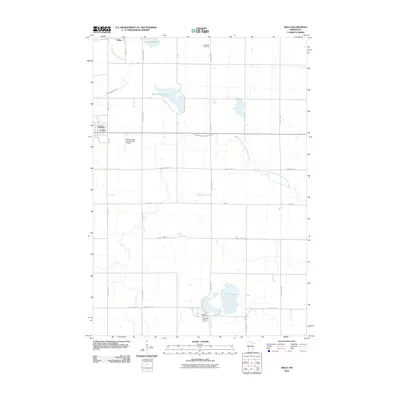
2010 Map of Arco
USGS Topo · Published 2010About this map
The settlement of Arco and the western edge of Ivanhoe anchor this landscape in Lincoln County, Minnesota. Defined by the winding paths of the Yellow Medicine River and its South Branch, the area transitions from established town centers to open prairie and agricultural land. Significant water bodies including Lake Stay, Hawks Nest Lake, and Drietz Lake punctuate the grid of county highways and local roads, illustrating the region's post-glacial topography. Cultural and civic landmarks such as the Icelandic Cemetery and the Mulder Field Incorporated Airport provide insights into the local history and infrastructure of the early 21st century. The map also documents the functional hearts of these communities through the Ivanhoe Post Office and the Arco Post Office, reflecting the enduring rural network of the Upper Midwest.
Find a feature on this map
25 named features on this map. Tap any name to fly to it.
Don’t see what you’re looking for? This feature index may not catch every label — zoom into the map to look around manually.
Map Details
Editions of this 2010 Arco Map
This is the sole edition of this map. No revisions or reprints were ever made.
Other maps of this area

1953 · Watertown
USGS Topo · 1:250,000

1958 · Watertown
USGS Topo · 1:250,000

1963 · Dead Coon Lake
USGS Topo · 1:24,000

1963 · Gislason Lake
USGS Topo · 1:24,000

1963 · Tyler
USGS Topo · 1:24,000

1963 · Arco
USGS Topo · 1:24,000
1967 · Porter SW
USGS Topo · 1:24,000

1967 · Lake Benton
USGS Topo · 1:24,000
1967 · Taunton
USGS Topo · 1:24,000

1967 · Canby SE
USGS Topo · 1:24,000