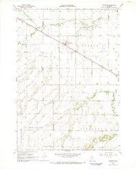
1967 Map of Taunton
USGS Topo · Published 1968About this map
The prairie landscape of western Minnesota is defined by the winding course of the Yellow Medicine River and its major tributaries, the North Branch Yellow Medicine River and South Branch Yellow Medicine River. The small settlement of Taunton serves as a focal point, situated along the straight-line track of the Chicago and North Western railroad which cuts diagonally across the townships of Alta Vista and Eidsvold. This region, surveyed in the mid-1960s, reflects a deep-rooted agricultural and rural community structure, organized into distinct townships including Limestone and Nordland. For those tracing local heritage, the map identifies specific landmarks like Hemnes Ch and localized industrial activity indicated by a Gravel Pit. The boundary between Lincoln and Lyon Counties divides the terrain, illustrating the grid-based development of the Upper Midwest.
Find a feature on this map
13 named features on this map. Tap any name to fly to it.
Don’t see what you’re looking for? This feature index may not catch every label — zoom into the map to look around manually.
Map Details
Editions of this 1967 Taunton Map
This is the sole edition of this map. No revisions or reprints were ever made.
Other maps of this area

1953 · Watertown
USGS Topo · 1:250,000

1953 · New Ulm
USGS Topo · 1:250,000

1957 · New Ulm
USGS Topo · 1:250,000

1958 · New Ulm
USGS Topo · 1:250,000

1958 · Watertown
USGS Topo · 1:250,000

1963 · Gislason Lake
USGS Topo · 1:24,000

1963 · Lynd
USGS Topo · 1:24,000

1963 · Arco
USGS Topo · 1:24,000

1967 · New Ulm
USGS Topo · 1:250,000

1967 · Minneota
USGS Topo · 1:24,000