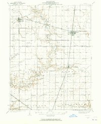
1935 Map of Arcola
USGS Topo · Published 1965About this map
The Kaskaskia River snakes through this Central Illinois landscape, defining the rural character of Douglas and Coles counties in the 1930s. The region is anchored by the established settlements of Arthur and Arcola, where the Pennsylvania and Illinois Central railroads intersect. This map reveals a dense network of one-room schoolhouses that once served the agricultural community, including uniquely named sites like Fuller Point Sch, Business Knoll Sch, and Swayback Sch. Religious life is evidenced by the Zoar Ch and Mt Zion Ch located near the river's winding path. The intricate survey details reflect a highly organized farming district, with small family-named landmarks like the Yoder Cem and Smith Cem providing essential clues for local genealogical research and property history.
Find a feature on this map
82 named features on this map. Tap any name to fly to it.
Don’t see what you’re looking for? This feature index may not catch every label — zoom into the map to look around manually.
Map Details
Editions of this 1935 Arcola Map
3 editions found
Other maps of this area

1933 · Toledo
USGS Topo · 1:62,500

1934 · Mattoon
USGS Topo · 1:62,500

1935 · Arcola
USGS Topo · 1:48,000

1935 · Sullivan
USGS Topo · 1:48,000

1936 · Oakland
USGS Topo · 1:48,000

1937 · Mattoon
USGS Topo · 1:62,500

1938 · Toledo
USGS Topo · 1:62,500

1940 · Sullivan
USGS Topo · 1:62,500

1940 · Arcola
USGS Topo · 1:62,500

1942 · Oakland
USGS Topo · 1:62,500