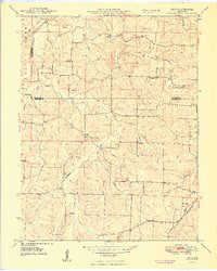
1948 Map of Argo
USGS Topo · Published 1948About this map
The Little Bourbeuse River and its numerous tributaries, including Opossum Creek and Boone Creek, carve through this section of the Missouri Ozarks where the borders of Gasconade, Franklin, and Crawford counties meet. This late 1940s landscape is defined by its rural infrastructure, featuring a high density of country schools such as Argo Sch, Delhi Sch, and Stringtown Sch. The small settlements of Argo and Japan serve as local anchors, each surrounded by family and community landmarks like the Japan Cem and Bacon Cem.
Find a feature on this map
36 named features on this map. Tap any name to fly to it.
Don’t see what you’re looking for? This feature index may not catch every label — zoom into the map to look around manually.
Map Details
Editions of this 1948 Argo Map
4 editions found
Other maps of this area

1903 · Sullivan
USGS Topo · 1:125,000

1935 · Gerald
USGS Topo · 1:48,000

1941 · Gerald
USGS Topo · 1:62,500

1944 · Gerald
USGS Topo · 1:62,500

1946 · Union
USGS Topo · 1:62,500

1947 · Sullivan
USGS Topo · 1:62,500

1948 · Cuba
USGS Topo · 1:24,000

1948 · Leasburg
USGS Topo · 1:24,000

1948 · Argo
USGS Topo · 1:24,000

1948 · Union
USGS Topo · 1:62,500