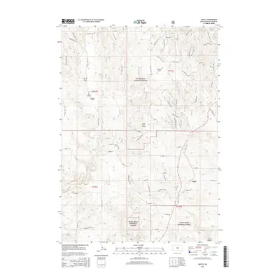
2015 Map of Argyle
USGS Topo · Published 2015About this map
Black Hills National Forest land dominates this western South Dakota landscape, characterized by a series of deep drainages and canyon systems. The settlement of Argyle sits at a junction of roads in the southeastern portion of the map, situated near the head of Argyle Canyon. The local terrain is defined by dramatic geographic features like Red Canyon and Cold Brook Canyon, which slice through the timbered hills. For those tracing the early transportation and recreation history of Custer County, the map highlights the winding path of the Mickelson Trl as it follows the historical rail corridor. Water sources like Dallan Spring and Upper Hand Spring are noted throughout the forest, while family-named landmarks such as Hopkins Flats and Pleasant Valley indicate early settlement patterns and ranching history in the Black Hills.
Find a feature on this map
61 named features on this map. Tap any name to fly to it.
Don’t see what you’re looking for? This feature index may not catch every label — zoom into the map to look around manually.
Map Details
Editions of this 2015 Argyle Map
This is the sole edition of this map. No revisions or reprints were ever made.
Other maps of this area

1896 · Harney Peak
USGS Topo · 1:125,000

1901 · Harney Peak
USGS Topo · 1:125,000

1902 · Edgemont
USGS Topo · 1:125,000

1950 · Edgemont NE
USGS Topo · 1:24,000

1950 · Minnekahta
USGS Topo · 1:24,000

1951 · Minnekahta NE
USGS Topo · 1:24,000

1954 · Fourmile
USGS Topo · 1:24,000

1954 · Jewel Cave SE
USGS Topo · 1:24,000

1955 · Jewel Cave
USGS Topo · 1:24,000
1955 · Argyle
USGS Topo · 1:24,000