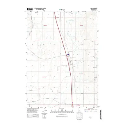
2013 Map of Arimo
USGS Topo · Published 2013About this map
Arimo serves as a central hub in this valley landscape, situated where the Portneuf River and Marsh Creek systems converge. The area is defined by its extensive water management infrastructure, most notably the Portneuf Marsh Valley Canal and Arimo Ditch, which trace the base of the rising terrain to the east. Smaller settlements like Robin and Marsh Center are connected by a grid of rural roads such as W Arimo Rd and S Old Highway 91, reflecting the long-standing agricultural character of the region. Local history and genealogy are anchored by landmarks like the Marsh Center Cemetery, while the eastern edge of the quadrangle transitions into more varied topography at Rough Canyon and Nats Canyon. The map provides a detailed view of the drainage patterns and transportation corridors that have shaped this portion of Marsh Valley over the decades.
Find a feature on this map
68 named features on this map. Tap any name to fly to it.
Don’t see what you’re looking for? This feature index may not catch every label — zoom into the map to look around manually.
Map Details
Editions of this 2013 Arimo Map
This is the sole edition of this map. No revisions or reprints were ever made.
Other maps of this area

1954 · Pocatello
USGS Topo · 1:250,000

1958 · Pocatello
USGS Topo · 1:250,000

1968 · Downey West
USGS Topo · 1:24,000

1968 · Wakley Peak
USGS Topo · 1:24,000
1968 · Downey East
USGS Topo · 1:24,000

1968 · Hawkins
USGS Topo · 1:24,000

1968 · Lava Hot Springs
USGS Topo · 1:24,000
1968 · Arimo
USGS Topo · 1:24,000
1968 · Haystack Mtn
USGS Topo · 1:24,000

1968 · Mc Cammon
USGS Topo · 1:24,000