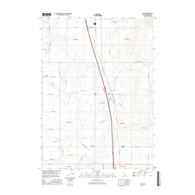
2017 Map of Arimo
USGS Topo · Published 2017About this map
Marsh Valley serves as the central geographic feature of this Bannock County landscape, defined by the winding course of Marsh Creek and an extensive network of irrigation and water management infrastructure. The settlement of Arimo sits prominently along the eastern edge of the valley floor, where a concentration of local roads like School Street and North Front Street anchor the community. To the west, the smaller settlement of Robin rests at the base of the rising hills, connected to the valley via West Arimo Road.
Find a feature on this map
63 named features on this map. Tap any name to fly to it.
Don’t see what you’re looking for? This feature index may not catch every label — zoom into the map to look around manually.
Map Details
Editions of this 2017 Arimo Map
This is the sole edition of this map. No revisions or reprints were ever made.
Other maps of this area

1954 · Pocatello
USGS Topo · 1:250,000

1958 · Pocatello
USGS Topo · 1:250,000

1968 · Downey West
USGS Topo · 1:24,000

1968 · Wakley Peak
USGS Topo · 1:24,000
1968 · Downey East
USGS Topo · 1:24,000

1968 · Hawkins
USGS Topo · 1:24,000

1968 · Lava Hot Springs
USGS Topo · 1:24,000
1968 · Arimo
USGS Topo · 1:24,000
1968 · Haystack Mtn
USGS Topo · 1:24,000

1968 · Mc Cammon
USGS Topo · 1:24,000