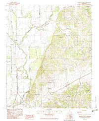
1983 Map of Arkabutla West
USGS Topo · Published 1983About this map
Arkabutla Lake dominates the northeastern corner of this Northwest Mississippi landscape, where the Coldwater River meanders toward the Tunica and De Soto county lines. The transition from the rugged eastern hills to the flatter alluvial lands to the west is marked by a network of drainage bayous, including Cormorant Bayou and Buck Island Bayou. The settlement pattern follows the Illinois Central Gulf railroad line, which connects the rural communities of Prichard and Savage.
Find a feature on this map
33 named features on this map. Tap any name to fly to it.
Don’t see what you’re looking for? This feature index may not catch every label — zoom into the map to look around manually.
Map Details
Editions of this 1983 Arkabutla West Map
This is the sole edition of this map. No revisions or reprints were ever made.
Other maps of this area

1908 · Hollywood
USGS Topo · 1:24,000

1908 · Walnut Lake
USGS Topo · 1:24,000

1910 · Walnut Lake
USGS Topo · 1:31,680

1913 · Hollywood
USGS Topo · 1:31,680

1931 · Horseshoe Lake
USGS Topo · 1:62,500

1932 · Horn Lake
USGS Topo · 1:48,000

1932 · Crenshaw
USGS Topo · 1:62,500

1935 · Crenshaw
USGS Topo · 1:62,500

1935 · Horn Lake
USGS Topo · 1:62,500

1939 · Clayton
USGS Topo · 1:62,500