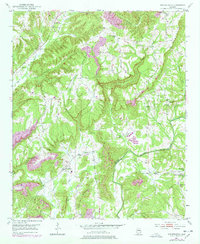
1951 Map of Arkadelphia
USGS Topo · Published 1978About this map
Arkadelphia and Bremen anchor this survey of the southern Cullman County highlands, situated where the terrain begins to drop toward the winding Mulberry Fork. The landscape is defined by the prominent heights of Arkadelphia Mountain and Prospect Mountain, which are cut by an intricate network of drainages including Sullivan Creek and James Creek. This 1951 record, which includes 1970s revisions, illustrates a rural economy transitioning through the mid-20th century. While the map shows traditional community centers like The Colony and several country schools such as McDonald Sch, it also documents industrial shifts through the presence of a Strip Mine and a local Landing Strip. The density of rural institutions is remarkable, with numerous local landmarks including Dorsey Creek Ch, Mt Joy Ch, and Sulphur Springs Ch serving as vital points of reference for genealogists and local historians.
Find a feature on this map
39 named features on this map. Tap any name to fly to it.
Don’t see what you’re looking for? This feature index may not catch every label — zoom into the map to look around manually.
Map Details
Editions of this 1951 Arkadelphia Map
5 editions found

Other maps of this area

1888 · Cullman
USGS Topo · 1:125,000

1889 · Birmingham
USGS Topo · 1:125,000

1892 · Cullman
USGS Topo · 1:125,000

1892 · Birmingham
USGS Topo · 1:125,000

1893 · Jasper
USGS Topo · 1:125,000

1895 · Birmingham
USGS Topo · 1:125,000

1907 · Birmingham
USGS Topo · 1:125,000

1949 · Sipsey
USGS Topo · 1:24,000

1949 · Cold Springs
USGS Topo · 1:24,000

1951 · Cold Springs
USGS Topo · 1:24,000