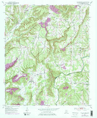
1951 Map of Arkadelphia
USGS Topo · Published 1978About this map
Arkadelphia Mountain and Prospect Mountain dominate this landscape in southern Cullman Co, where the Mulberry Fork carves a deep winding path through the plateau. At the midpoint of the century, the settlement of Arkadelphia serves as a local hub near the Landing Strip, while The Colony and Bremen anchor the surrounding rural community. The area is dense with local landmarks of genealogical interest, including the McDonald Cem and a high concentration of country houses of worship like Shelton Grove Ch and Dorsey Creek Ch. This survey, based on 1947 aerial photography and field-checked in 1951, reflects the post-war rural infrastructure of Alabama before major modernization changed the local character. Educational and social centers like New Prospect Sch and Colony Sch are clearly marked alongside the rugged drainages of Dorsey Creek and Rice Creek.
Find a feature on this map
34 named features on this map. Tap any name to fly to it.
Don’t see what you’re looking for? This feature index may not catch every label — zoom into the map to look around manually.
Map Details
Editions of this 1951 Arkadelphia Map
5 editions found

Other maps of this area

1888 · Cullman
USGS Topo · 1:125,000

1889 · Birmingham
USGS Topo · 1:125,000

1892 · Cullman
USGS Topo · 1:125,000

1892 · Birmingham
USGS Topo · 1:125,000

1893 · Jasper
USGS Topo · 1:125,000

1895 · Birmingham
USGS Topo · 1:125,000

1907 · Birmingham
USGS Topo · 1:125,000

1949 · Sipsey
USGS Topo · 1:24,000

1949 · Cold Springs
USGS Topo · 1:24,000

1951 · Cold Springs
USGS Topo · 1:24,000