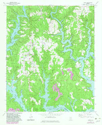
1969 Map of Arley
USGS Topo · Published 1983About this map
The town of Arley and the surrounding woodlands of the William B Bankhead National Forest define this landscape, heavily shaped by the intricate shoreline of Lewis Smith Lake. Mapping from 1969, with subsequent revisions in the early 1980s, reveals a community anchored by local institutions like Meek High Sch and Meek Ch. The geography is dominated by the many branches of the lake, including the Sipsey Fork and Dismal Creek, which create deep inlets and isolated peninsulas throughout the quadrangle.
Find a feature on this map
35 named features on this map. Tap any name to fly to it.
Don’t see what you’re looking for? This feature index may not catch every label — zoom into the map to look around manually.
Map Details
Editions of this 1969 Arley Map
2 editions found
Other maps of this area

1893 · Jasper
USGS Topo · 1:125,000

1949 · Cold Springs
USGS Topo · 1:24,000

1949 · Manchester
USGS Topo · 1:24,000

1949 · Sunlight
USGS Topo · 1:24,000

1950 · Manchester
USGS Topo · 1:24,000

1951 · Cold Springs
USGS Topo · 1:24,000
1951 · Sunlight
USGS Topo · 1:24,000

1953 · Birmingham
USGS Topo · 1:250,000

1956 · Birmingham
USGS Topo · 1:250,000

1956 · Gadsden
USGS Topo · 1:250,000