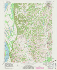
1970 Map of Arlington
USGS Topo · Published 1983About this map
The Mississippi River creates a dynamic western boundary for this 1970s landscape, where the floodplain is defined by an intricate network of backwaters including Forked Lake, Crooked Lake, and Goose Pond. High on the bluffs overlooking the river, Columbus-Belmont State Park and the settlement of Columbus mark a site of significant strategic importance. The topography shifts dramatically from the flat alluvial lands of Belmont Landing to the deeply dissected hills of the interior, where small communities like Berkley and Arlington are connected by the Illinois Central Gulf railroad line.
Find a feature on this map
56 named features on this map. Tap any name to fly to it.
Don’t see what you’re looking for? This feature index may not catch every label — zoom into the map to look around manually.
Map Details
Editions of this 1970 Arlington Map
Other maps of this area

1939 · Wickliffe
USGS Topo · 1:62,500

1939 · Hickman
USGS Topo · 1:62,500

1951 · Blandville
USGS Topo · 1:24,000

1951 · Oakton
USGS Topo · 1:24,000

1951 · Wolf Island
USGS Topo · 1:24,000

1951 · Wickliffe SW
USGS Topo · 1:24,000

1951 · Arlington
USGS Topo · 1:24,000

1951 · Wickliffe
USGS Topo · 1:24,000

1951 · Milburn
USGS Topo · 1:24,000

1952 · Clinton
USGS Topo · 1:24,000