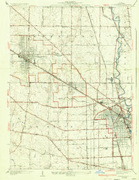
1927 Map of Arlington Heights
USGS Topo · Published 1934About this map
Arlington Heights and Mt Prospect anchor a landscape of emerging rail suburbs and agricultural pockets northwest of Chicago in the mid-1920s. The grid patterns of these growing towns contrast with the surrounding townships of Wheeling and Elk Grove, where family-named landmarks like Schnells Corner and rural institutions such as the Wilson School remain prominent. The Chicago and Northwestern railroad serves as the primary artery through this corridor, facilitating the residential expansion visible in the residential blocks near Des Plaines. Along the eastern edge, the Des Plaines River winds past Feehanville and the significant campus of St Marys Training School. For genealogists, the map reveals several burial sites including the English Cemetery and the extensive All Saints Cemetery, alongside numerous schoolhouses and local roads that shaped daily life before the mid-century highway boom.
Find a feature on this map
67 named features on this map. Tap any name to fly to it.
Don’t see what you’re looking for? This feature index may not catch every label — zoom into the map to look around manually.
Map Details
Editions of this 1927 Arlington Heights Map
3 editions found
Other maps of this area

1891 · Riverside
USGS Topo · 1:62,500

1893 · Riverside
USGS Topo · 1:62,500

1900 · Riverside
USGS Topo · 1:62,500

1900 · Highwood
USGS Topo · 1:62,500

1901 · Riverside
USGS Topo · 1:62,500

1908 · Wheaton
USGS Topo · 1:62,500

1923 · Barrington
USGS Topo · 1:62,500

1927 · Arlington Heights
USGS Topo · 1:24,000

1928 · Elmhurst
USGS Topo · 1:24,000

1928 · Wheeling
USGS Topo · 1:24,000