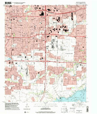
1995 Map of Arlington
USGS Topo · Published 2002About this map
Arlington and Grand Prairie dominate this mid-1990s landscape, showing the intensive suburban development and infrastructure across the Tarrant and Dallas County line. The map captures a moment of significant institutional presence, featuring the campus of Arlington State College and the large industrial and transportation corridor between the two cities. Major transport hubs like the Municipal Airport and the Arlington Municipal Airport are clearly delineated alongside a dense network of residential streets and schools such as St Maria Goretti School and Bowie School.
Find a feature on this map
95 named features on this map. Tap any name to fly to it.
Don’t see what you’re looking for? This feature index may not catch every label — zoom into the map to look around manually.
Map Details
Editions of this 1995 Arlington Map
This is the sole edition of this map. No revisions or reprints were ever made.
Other maps of this area

1891 · Dallas
USGS Topo · 1:125,000

1893 · Dallas
USGS Topo · 1:125,000

1894 · Fort Worth
USGS Topo · 1:125,000

1931 · Carrollton
USGS Topo · 1:62,500

1931 · Grapevine
USGS Topo · 1:62,500

1954 · Dallas
USGS Topo · 1:250,000

1958 · Dallas
USGS Topo · 1:250,000

1959 · Kennedale
USGS Topo · 1:24,000

1959 · Arlington
USGS Topo · 1:24,000

1959 · Euless
USGS Topo · 1:24,000
Featured Places
- Arlington, TX
- Grand Prairie, TX
- Lakewood, Grand Prairie
- Ameserio Estates, Grand Prairie
- Westchester, Grand Prairie