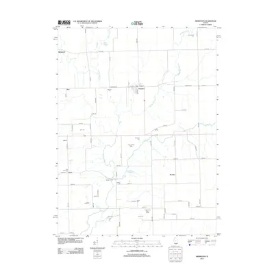
2012 Map of Armington
USGS Topo · Published 2012About this map
Armington serves as the primary hub of this rural landscape in central Illinois, where a complex network of tributaries including the W Fork Sugar Cr and Middle Fork Sugar Cr converge toward Sugar Cr. The map reveals a high density of small family or community burial grounds, such as Hieronymous Cem, Oak View Cem, and Union Station Cem, indicating a long history of local settlement and genealogical depth. Small aviation facilities like the Sugar Creek Farm Airport and Feist Landing Strip reflect the intersection of modern agricultural logistics with the traditional farmstead grid. Named locations like Mountjoy and Lucas appear alongside river crossings such as Morgan Bridge, showing how the early 21st-century road system follows the established paths of older cross-country travel.
Find a feature on this map
71 named features on this map. Tap any name to fly to it.
Don’t see what you’re looking for? This feature index may not catch every label — zoom into the map to look around manually.
Map Details
Editions of this 2012 Armington Map
This is the sole edition of this map. No revisions or reprints were ever made.
Other maps of this area

1911 · Lincoln
USGS Topo · 1:62,500

1913 · Lincoln
USGS Topo · 1:62,500

1949 · Mc Lean
USGS Topo · 1:62,500

1951 · McLean
USGS Topo · 1:62,500

1951 · Minier
USGS Topo · 1:62,500

1957 · Kenney
USGS Topo · 1:62,500

1958 · Peoria
USGS Topo · 1:250,000

1961 · Peoria
USGS Topo · 1:250,000

1963 · Peoria
USGS Topo · 1:250,000
1971 · Hopedale
USGS Topo · 1:24,000