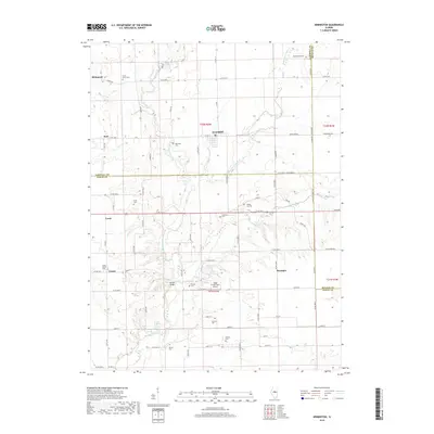
2018 Map of Armington
USGS Topo · Published 2018About this map
Armington serves as the central hub of this Central Illinois landscape, where the rural topography is defined by the meandering courses of Sugar Creek and its branches, including the W Fork Sugar Cr and Middle Fork Sugar Creek. The map documents a dense network of family-named cemeteries and landmarks that speak to the deep-rooted genealogy of Tazewell, McLean, and Logan Counties. These sites, such as Hittle Grove Cem and Hieronymous Cem, are scattered among small settlements like Richmond, Burt, and Union. Modern infrastructure, such as the Sugar Creek Farm Airport, exists alongside older landmarks like Morgan Bridge and Gold Spring, illustrating the steady evolution of this agricultural region. The grid of county roads and historic routes like Dixie Rd provides the primary structure for the area's ongoing development.
Find a feature on this map
52 named features on this map. Tap any name to fly to it.
Don’t see what you’re looking for? This feature index may not catch every label — zoom into the map to look around manually.
Map Details
Editions of this 2018 Armington Map
This is the sole edition of this map. No revisions or reprints were ever made.
Other maps of this area

1911 · Lincoln
USGS Topo · 1:62,500

1913 · Lincoln
USGS Topo · 1:62,500

1949 · Mc Lean
USGS Topo · 1:62,500

1951 · McLean
USGS Topo · 1:62,500

1951 · Minier
USGS Topo · 1:62,500

1957 · Kenney
USGS Topo · 1:62,500

1958 · Peoria
USGS Topo · 1:250,000

1961 · Peoria
USGS Topo · 1:250,000

1963 · Peoria
USGS Topo · 1:250,000
1971 · Hopedale
USGS Topo · 1:24,000