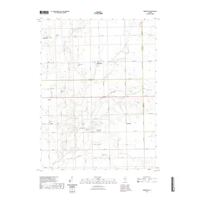
2021 Map of Armington
USGS Topo · Published 2021About this map
Armington serves as the central hub of this agricultural landscape where the borders of Tazewell, Logan, and McLean counties converge. The terrain is defined by the winding course of Sugar Creek and its various branches, including the Middle Fork Sugar Creek and West Fork Sugar Creek. A dense network of section-line roads connects the small clusters of Richmond, Burt, Union, and Mountjoy. For those tracing local families, the map provides a remarkable concentration of burial grounds, such as Hittle Grove Cemetery, Miller Hasenmeyer Cemetery, and the Hieronymus Cemetery in the north. The area's rural infrastructure is further highlighted by the Sugar Creek Farm Airport and several localized water features like Minier Lake and Gold Spring, reflecting a long-established pattern of midwestern prairie settlement and land use.
Find a feature on this map
58 named features on this map. Tap any name to fly to it.
Don’t see what you’re looking for? This feature index may not catch every label — zoom into the map to look around manually.
Map Details
Editions of this 2021 Armington Map
This is the sole edition of this map. No revisions or reprints were ever made.
Other maps of this area

1911 · Lincoln
USGS Topo · 1:62,500

1913 · Lincoln
USGS Topo · 1:62,500

1949 · Mc Lean
USGS Topo · 1:62,500

1951 · McLean
USGS Topo · 1:62,500

1951 · Minier
USGS Topo · 1:62,500

1957 · Kenney
USGS Topo · 1:62,500

1958 · Peoria
USGS Topo · 1:250,000

1961 · Peoria
USGS Topo · 1:250,000

1963 · Peoria
USGS Topo · 1:250,000
1971 · Hopedale
USGS Topo · 1:24,000