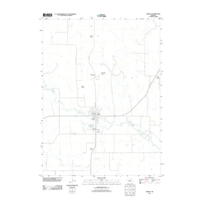
2011 Map of Arnold
USGS Topo · Published 2011About this map
The South Loup River winds through this Nebraska landscape, anchoring the settlement of Arnold at a vital crossroads. This 2011 survey illustrates the town's social and recreational layout, featuring the Arnold Post Office and the Arnold 9 Hole Golf Course alongside the river's edge. To the south, the Arnold Lake State Recreation Area surrounds Arnold Lake, providing a clear view of the water management and conservation efforts in the valley. The map reveals a transition from the agricultural plateaus of Judkins Table in the north to the more complex topography of Devils Den Canyon and its associated Devils Den Lookout. Local history is preserved in the placement of the Arnold Cemetery and the more remote Powell Canyon Cemetery, which reflect the community's roots in Custer County. The rural grid is defined by named routes such as Mills Valley Rd and Dunning Rd, showing how transportation networks navigate the surrounding Yucca Valley.
Find a feature on this map
22 named features on this map. Tap any name to fly to it.
Don’t see what you’re looking for? This feature index may not catch every label — zoom into the map to look around manually.
Map Details
Editions of this 2011 Arnold Map
This is the sole edition of this map. No revisions or reprints were ever made.
Other maps of this area

1948 · Linscott
USGS Topo · 1:62,500

1950 · Linscott
USGS Topo · 1:62,500

1951 · Hoagland
USGS Topo · 1:62,500

1954 · North Platte
USGS Topo · 1:250,000

1956 · North Platte
USGS Topo · 1:250,000

1957 · North Platte
USGS Topo · 1:250,000

1967 · North Platte
USGS Topo · 1:250,000
1972 · Davenport Table
USGS Topo · 1:24,000
1972 · Murphy Table
USGS Topo · 1:24,000

1972 · Logan
USGS Topo · 1:24,000