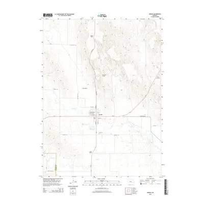
2014 Map of Arnold
USGS Topo · Published 2014About this map
S Loup River meanders through the heart of this Custer County landscape, framing the settlement of Arnold at the junction of Ne-92 and Ne-40. The town's grid is detailed with residential streets such as W Madison Ave and S Carroll St, leading out toward Arnold Lake and the Arnold Cem. The surrounding terrain transitions from the high, flat expanse of Judkins Table in the north to the depressions of Devils Den Canyon and the southern Yucca Valley. Local history is anchored by the rural Mills Valley and outlying landmarks like Powell Canyon Cem, while the county line between Lincoln Co and Custer Co is clearly marked in the southwest corner. The road network, including Garfield Table Rd and Dunning Rd, illustrates the connectivity between these remote tablelands and the river valley community.
Find a feature on this map
31 named features on this map. Tap any name to fly to it.
Don’t see what you’re looking for? This feature index may not catch every label — zoom into the map to look around manually.
Map Details
Editions of this 2014 Arnold Map
This is the sole edition of this map. No revisions or reprints were ever made.
Other maps of this area

1948 · Linscott
USGS Topo · 1:62,500

1950 · Linscott
USGS Topo · 1:62,500

1951 · Hoagland
USGS Topo · 1:62,500

1954 · North Platte
USGS Topo · 1:250,000

1956 · North Platte
USGS Topo · 1:250,000

1957 · North Platte
USGS Topo · 1:250,000

1967 · North Platte
USGS Topo · 1:250,000
1972 · Davenport Table
USGS Topo · 1:24,000
1972 · Murphy Table
USGS Topo · 1:24,000

1972 · Logan
USGS Topo · 1:24,000