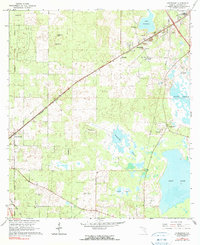
1966 Map of Arredondo
USGS Topo · Published 1990About this map
Arredondo and its surrounding wetlands define this Alachua County landscape during the mid-1960s, a period characterized by quiet rural settlements and active industrial extraction. The community of Arredondo is a focal point for local genealogy, featuring several landmarks such as St Lukes Ch, Elim Ch, and New Salem Ch. The northeastern corner shows early signs of suburban transition near Stengel Airport, while the south and west remain dominated by the broad, low-lying basins of Paynes Prairie, Kanapaha Prairie, and Levy Lake.
Find a feature on this map
31 named features on this map. Tap any name to fly to it.
Don’t see what you’re looking for? This feature index may not catch every label — zoom into the map to look around manually.
Map Details
Editions of this 1966 Arredondo Map
3 editions found

Other maps of this area

1890 · Arredondo
USGS Topo · 1:62,500

1892 · Arredondo
USGS Topo · 1:62,500

1894 · Arredondo
USGS Topo · 1:62,500

1895 · Williston
USGS Topo · 1:62,500

1954 · Gainesville
USGS Topo · 1:250,000

1955 · Bronson NE
USGS Topo · 1:24,000

1958 · Gainesville
USGS Topo · 1:250,000

1959 · Gainesville
USGS Topo · 1:250,000
1966 · Micanopy
USGS Topo · 1:24,000

1966 · Gainesville West
USGS Topo · 1:24,000